In this section you will find the following:
- Download GPX file
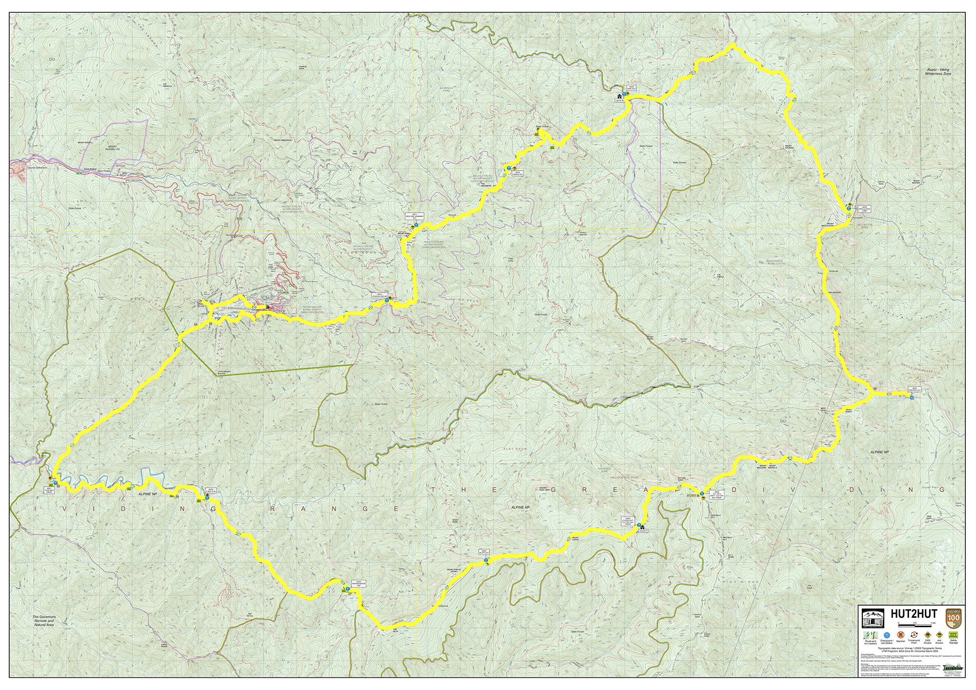
- Mandatory Avenza course map
- Direct Avenza Map link for adding to Avenza App on device:
https://link.avenza.com/gDbj - Course Marking Instruction
*click on the boxed frame, top right icon on map to enlarge to full screen view with options in Google Maps.
Terranium Topo Explorer - Open Course Map
AVENZA MAP download file (for Avenza App)

GPX downloadable file. The GPX can be used to navigate on a GPX / GPS compatible unit.
*use at your own risk.
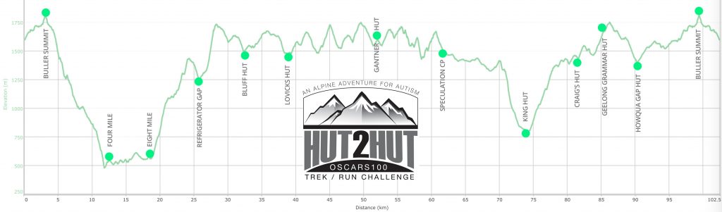
Click on the ELEVATION chart below for elevation map.
COURSE MARKING INSTRUCTIONS
Oscars 100 Hut2Hut takes place over a distance of 100km with most of the course passing through remote, thick, challenging wilderness areas. This is an adventure, after all.
You will travel along dirt roads (4WD / 2WD) for some stretches, while others will be formal way marked trails, such as the Australian Alpine Walking Track. Others again are 'trails' in that they can be found on maps, but as is the way with the Australian bush, that doesn't mean the way forward is obvious or clear in many parts. Even the AAWT can get closed in with thick brush at times and there can be animal tracks leading off to confuse (and signs aren't exactly prolific!).
To be clear, while we will be marking sections of the course and major intersections (only), we cannot and will not be marking the course heavily with 'confidence markers' as you may find at a shorter trail run / walk event. You will need have some confidence in being in the wilderness and keep your wits about you. You will need to think and make judgement calls and minor navigational decisions (with major consequences). This is NOT to say that you need to be an expert navigator or orienteering champ! You will be on gazetted trails, most of which have 'footfall markings' - that is, look down and you will see clear signs of foot traffic having passed along the route. Plus, you will have read up on the course (won't you?!).
What we are saying is that you need to know how to look at a map, recognise a trail, read topographical lines and generally get a sense of where you are according to a map and more importantly, where you need to get to.
 ON COURSE MARKING: will consist of red 'Tour de Trails' arrows used at major turning points and sometimes pink ribbon (although we will use this sparingly).
Sections on course to be mindful of as they will be the hardest to navigate:
- Four Mile Spur (on course from approx 2.5km mark through to 10.5km). Difficult terrain. No one will be running the first four kilometres. It is rocky underfoot, steep and closed in bush. Be alert and do not drop off either side of the spur. From approx 4km the going gets a little easier. But be mentally prepared for slow going in this section.
- Viking Wilderness Area - (on course from approx 51km through to 59km) good and clear going early on, but as you get closer to Mt Buggery and Mt Speculation, there are some sections where trail marking is non existent, and bush closes in tightly. Another good section to have your GPS Unit or mobile with Avenza open as you go.
- Muesli Spur - (on course from approx 67 -through 71km) turning left down off Mt Speculation 4WD road onto Muesli Spur Track, you will find some steep sections and some thick closed in section. Again, check your bearing and use your navigation aids here, especially if coming down in the dark.
As mandatory for ALL COMPETITORS, you need to have on your person / team
- Physical map of the course, preferably laminated and/or in waterproof slip. Self-supply. $15-$30. See online sales links below.
- Mobile phone, with spare battery charge, pre loaded with AVENZA MAPS APP with the course downloaded into the App. The beauty of this system is that you don't need regular phone reception for the map to work including a locator beacon telling you where you are in relation to the marked course. So really, you should never get off course - just turn on your phone, open the map within the App, and you can see on a topographical map where you are in relation to the course (hopefully on it!). Self-organise. FREE.
As optional you can also download the GPX file to upload on to your GPS-enabled device (GPS handheld unit with AU map installed is best, or use on your GPS-enabled watch (one with tracking ability).
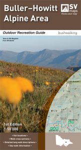
PHYSICAL MAPS: we suggest investing in the Outdoor Recreation series Buller-Howitt Alpine Area bushwalking map, 1:50,000, published by SV Maps. They give a level of detail as seen on the course sections found on The Trails page of this website. You can pre purchase this map today online via:
You can carry the map as is, or we also recommend scanning (or photographing) relevant course sections, printing out and laminating as easy-grab weatherproof cards.
AVENZA MAP DOWNLOAD INSTRUCTIONS
![]()
AVENZA MAPS - mapping App for Oscars Hut 2 Hut
Once set up, the app works WITHOUT mobile reception, locating you on a 1:50,000 topo map. You need to download the App onto your smartphone, then download the full high-res course map into the App.
Download the instructions as a PDF from the relevant link - print out if you need to:


MAP LINK FOR AVENZA
As per instructions in PDFs above, you will need to copy and paste this link below (long press on top of the link & select “copy”) to load the map into your Avenza App:
THE AVENZA MAP DOWNLOAD LINK IS BELOW OR HERE
USING AVENZA MAPS
To make full use of Avenza maps, GPS must be turned on in your device.
- On the map, key locations are marked with yellow labels, and the route is marked as a semi-transparent blue line.
- The latitude and longitude numbers at the bottom of screen correspond to the point that the cross-hairs are targeting at centre screen.
- Therefore, you can scroll around to any position on the map & determine the co-ordinates of the point between the cross-hairs.
- Your current GPS location is displayed on the map as a blue dot.
- Press the 'Location Button' to centre in on your current location. Once this is done, your current lat/long co-ordinates will match the lat/longs displayed on the screen. This will only work if you are physically located within the map boundaries.